infographic – ¡Vámonos!
 

Tag: infographic

Thanks to José García Sánchez in the Secondary MFL Matters Facebook group for this lovely infographic/ map of European present givers. Whilst Christmas is past for most, Spain and those who follow the Orthodox calendar have another day or so before they receive their gifts on 6th January or Epiphany. I’ll certainly be thinking of activities to use this next year, perhaps preparing comprehension questions based around practising name of countries and / or nationalities but I’ll also be using it as soon as we go back to school as a way of eking out one last activity from the array of Christmas cards and greetings we received as part of our eTwinning projects.

Below are some images of our cards, temporarily taking over the Achievement Tree!

¡Ponchos!

| Leave a comment

Gaucho salteno Find out more about gauchos here.

Thanks to Vicky Cooke for sharing this lovely image this morning and the luxury of a train journey to London and back on which it write this post!

Whilst Intercultural Understanding (ICU) is no longer an explicit section of the Languages Programme of Study, it opens with the following words:

Learning a foreign language is a liberation from insularity and provides an opening to other cultures. A high-quality languages education should foster pupils’ curiosity and deepen their understanding of the world.

I firmly believe that learning a language needs a context to bring it to life, and that context should not be limited to Spain for Spanish, France for French or Germany for German; the latter all the more important to me as I learned German in Switzerland! So I’m always looking for ideas to incorporate an aspect of ‘culture’ into activities. What’s more, learners really enjoy such activities. Clare has some marvellous ones on Light Bulb Languages such distances between Spanish cities to practice large numbers, Moorish tiles to look at shape and colour, Saints days to practice saying the date and so on. In fact there’s a whole section of resources marked ‘Intercultural understanding’ that includes Guatemalan worry dolls, Aztec codices and Mayan maths.

I’m about to start a unit on colour and shape with Y3 and, with a long-ish half term, Y4 are going to finish their topic early too so I’ve been looking for a little something to fill a gap. I was therefore pleased to see Vicky’s post this morning which sparked an idea. Can’t say it was earth shatteringly original but it was a good idea nonetheless (Vicky had it too!)


The above map plus the one on the left show the ponchos worn across Argentina  and I’ve so far thought of the following:

1. Knowledge of Argentina – count the provinces, name them, pronounce them. Countries that border Argentina.
2. Compass points / prepositionsSanta Cruz está en el sur de Argentina. Jujuy está en el norte de Argentina en la frontera con Chile y Bolivia. Entre Ríos está en el este al norte de Buenos Aires. 
3. Colour – giving the name of a place and requiring the colour(s) in response, either in a single word, a phrase or a sentence. Soy de Chubut ¿de qué color es mi poncho? or ¿De qué color es el poncho típico de San Luis? – blanco y naranja/Es blanco y naranja/El poncho típico de San Luis es blanco y naranja.
4. Pattern¿Cómo es el poncho de Salta? Es rojo con una franja negra en el cuello y en el borde. This site gives a description of some in English as well as historical information about ponchos. And here is a more extensive article in Spanish.
5. Combining all the above. Soy de Neuquen. Está en el oeste de Argentina, en la frontera con Chile, al norte de Río Negro, al sur de Mendoza y al oeste de La Pampa. El poncho típico de Neuquén es blanco con puntos azules.

I’ve also found more useful graphics on this subject:

A chart of ponchos in three sections according to their geographical position in Argentina at would be even better for detailed descriptions.
A chart of traditional Mapuche patterns used in ponchos – it would be an interesting challenge to replicate these patterns using graph paper – cross curricular link with maths there!

See also http://matematicas-maravillosas.blogspot.co.uk/2011/07/puede-notarse-que-las-figuras-que.html 

A colour wheel giving some of the symbolism of wearing that particular colour.

6. Using the above, design your own poncho using traditional colours and patterns:
Mi poncho es …… El rojo significa ….. Tiene estampa…… Es como el poncho de ….
(A similar activity can be found on Light Bulb Languages for flags/banderas)

Here’s a blank poncho that you might use (or you might just like to draw your own!) NB this poncho is the wrong shape as is this one.
You could also make a mini gaucho out of a lolly stick or old fashioned clothes peg like the chap on the right!


I’ve saved some links on Pinterest – Argentinian ponchos including the image below.

If you like the original map, I’ve also found maps of Argentina giving animals according to region and mates too as well as a beautiful vintage map of Argentina with images depicting the terrain, industry, dress and wildlife of each area and an info graphic of ‘La Argentina, el país dé los seis continentes’, the slogan of an advertising campaign I’m 1998 that emphasises the diversity of Argentina. Finally, a map of 24 ‘must visit’ places in Argentina. Having never been there, I couldn’t say whether it’s a comprehensive list or whether there are other places to add?

Destinos imperdibles en la Argentina

¡24 destinos únicos en la Argentina!

Mapas

| 1 Comment

I’ve recently started a Pinterest of Spanish resources and came across some lovely maps as I was pinning. None of them would actually serve to guide your way so no good for directions really, but they sparked a few ideas!

map of spain
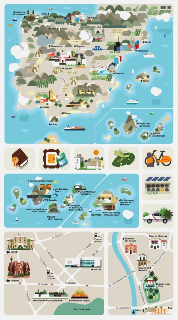
This map is a composite of a number of graphics used in an article on Spain. I like the stylised topography and selection of places of interest in various towns.

Possible activities

Name the monuments on the map of Spain.

Assign each group a monument to research.

Identify the mountain ranges. Which is tallest? What activities can be done in the mountains?

Give learners their own blank map of Spain and ask them to select places of interest, features such as rivers or lakes etc to mark on their own infographic map.


Screen Shot 2013-04-10 at 10.05.09

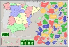
This isn’t an infographic, rather a site that is packed with interactive maps looking at the geography of Spain. You can try to name the rivers, mountains, autonomous regions, provinces and so on. I particularly like the provincias one above as the shapes give you a clue – they’re quite tricky puzzles!

Screen Shot 2013-04-07 at 20.54.09

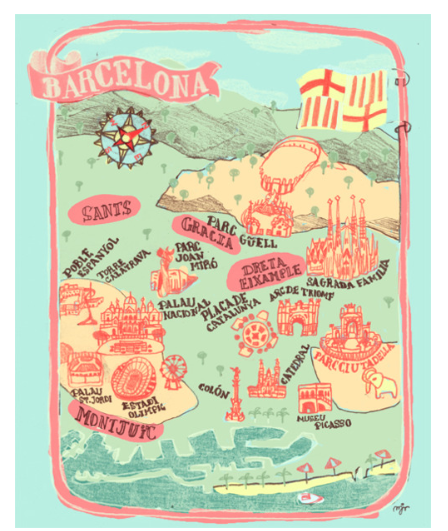
This map of Barcelona gives the vague geographical layout of several monuments and places of interest.

Possible activities 

Find the date that each of the monuments was built (practice of large numbers!)

Challenge learners to plan a visit that includes all or a selection of the places on the map using public transport. 

Draw a map of their town or a large city in the same style.

Screen Shot 2013-04-10 at 10.21.23

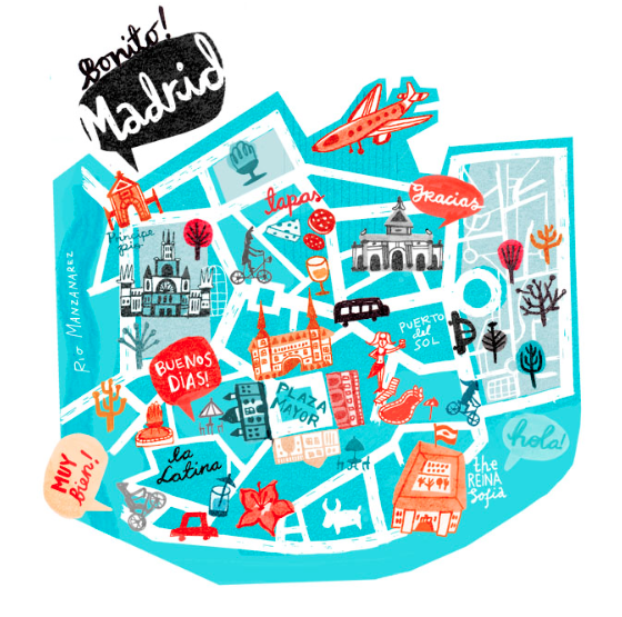
And this map of Madrid has even less geographical information but also includes some phrases that you might hear / use, and some ideas of things to do as well. There’s a similar map of Paris.

Possible activities

Design a similar map for your local area; which places would you recommend? what would you do? which phrases might sum up your area?

Compare the above with a plan of Madrid. Is it accurate? Discuss the differences using Group Talk phrases of opinions and agreement/disagreement.

Screen Shot 2013-04-07 at 20.57.39

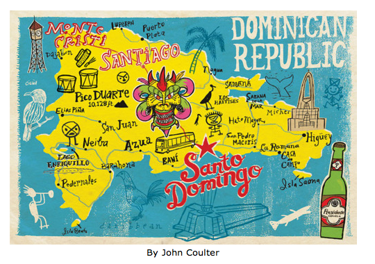
And then there are maps of Spanish speaking countries. This one of the Dominican Republic is possibly the nearest to an accurate map here.

Possible activities

Where is the Dominican Republic? How did it get its name?

There are ‘doodles’ all over the map. What are they?

Screen Shot 2013-04-10 at 10.26.44

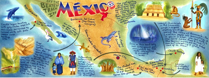
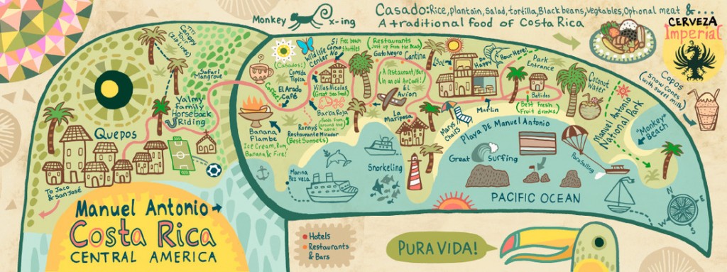
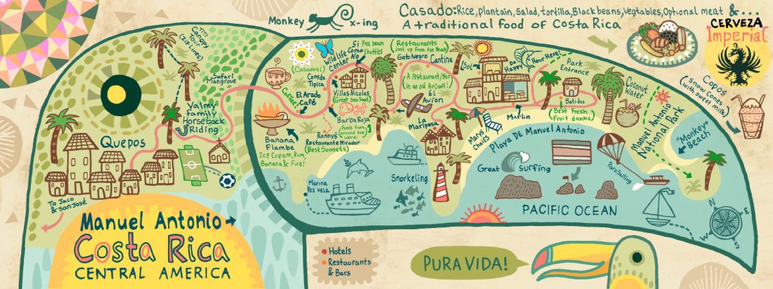
The maps above and below come from a site with lots of map /infographic images of Spanish speaking countries.

I like the use of colour in these maps.

Possible activities

Use the Mexico map to recommend activities to -a wildlife lover -a history buff -a thrill seeker

Make your own tourist map in the style of either map – off the beaten track activities, food you mustn’t miss, insider knowledge of the best coffee and so on.

Devise a slogan for your area like ‘Pura Vida’

costa rica

And if you don’t want to do activities with the maps, they makes lovely displays!

I have a feeling that I’ll be coming back to other infographics soon with more ideas …


A bonus post today as I’ve just had this great infographic brought to my attention by @HodderMFL and @jacksfeed

I like how the names of the present deliverer from around the world are written on the map as well as information about certain countries.

Click on the map and you can zoom in!

Just found this interesting infographic about the relationship between learning languages and your brain.

The bottom section about the optimum age for your brain to be most efficient at language learning is a strong case for Primary Languages (hurrah!) but not such good news for my attempts to learn German (boo!). It doesn’t say you can’t learn a langage when you’re old. Er. Although I will very shortly head off their scale…

via


One of the aspects of our Comenius Regio project that I have particularly enjoyed and that has given me great pleasure is the change in perceptions about being ‘foreign’ and by extension different.
Although pupils at WCPS are bright, and have had some contact with children in Spain previously, many still thought that every town in Spain was near a beach, that it was always hot, and that everyone steak and chips whilst speaking English. Their idea of a Spanish person was a lady with dark hair wearing a sevillanas dress or Lionel Messi (who isn’t Spanish!)
As one of the strands of the project was Intercultural Understanding, challenging and changing these perceptions has been key to the success of the project.
As pupils have met teachers from Barcelona in person, and children from Els Pins via Skype, and asked them questions, many things have dawned on them – for example,we all wear similar clothes, our food isn’t so different although we eat at different times and that we have many interests in common like sport and the environment. It’s also been noted that, whilst they do speak English quite well, people in Spain speak Spanish , but people in Barcelona also speak Catalan.
Now that we’re more aware about Spain- and India through Connecting Classrooms, being ‘different’ has become cool and there are several pupils who would never have ‘owned up’ to having another first language who are now wanting to share.
There’s always further to go of course and whilst this infographic is deliberately provocative, how many of the ‘perceptions’ can be identified as not just being held by Americans?
If we were to draw a similar map based on our perceptions, what would it look like?
Might be interesting to ask learners what they know and think, and then set about challenging the accuracy of their perceptions.
 
via

//

Interesting how different colours mean different things according to culture.

For example, no 16 – death – is represented by black in Western / American, Native American and Japanese or white in Hinduism and Chinese but silver in Muslim culture and green in South America.

Would make quite a fun activity finding similarities and differences.

via

¡Vámonos! ©2024. All Rights Reserved.
Powered by WordPress. Theme by Phoenix Web Solutions