
Original –
http://www.argentina-excepcion.com/en/maps-argentina/maps-argentina-chile/map-ponchos-argentina

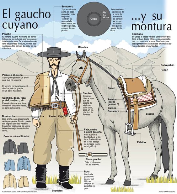
Gaucho salteno Find out more about gauchos here.
Thanks to Vicky Cooke for sharing this lovely image this morning and the luxury of a train journey to London and back on which it write this post!
Whilst Intercultural Understanding (ICU) is no longer an explicit section of the Languages Programme of Study, it opens with the following words:
Learning a foreign language is a liberation from insularity and provides an opening to other cultures. A high-quality languages education should foster pupils’ curiosity and deepen their understanding of the world.
I firmly believe that learning a language needs a context to bring it to life, and that context should not be limited to Spain for Spanish, France for French or Germany for German; the latter all the more important to me as I learned German in Switzerland! So I’m always looking for ideas to incorporate an aspect of ‘culture’ into activities. What’s more, learners really enjoy such activities. Clare has some marvellous ones on Light Bulb Languages such distances between Spanish cities to practice large numbers, Moorish tiles to look at shape and colour, Saints days to practice saying the date and so on. In fact there’s a whole section of resources marked ‘Intercultural understanding’ that includes Guatemalan worry dolls, Aztec codices and Mayan maths.
I’m about to start a unit on colour and shape with Y3 and, with a long-ish half term, Y4 are going to finish their topic early too so I’ve been looking for a little something to fill a gap. I was therefore pleased to see Vicky’s post this morning which sparked an idea. Can’t say it was earth shatteringly original but it was a good idea nonetheless (Vicky had it too!)
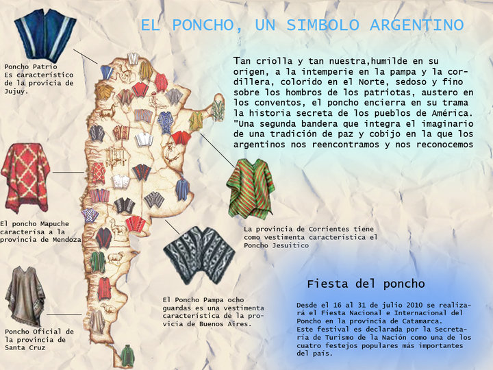
The above map plus the one on the left show the ponchos worn across Argentina and I’ve so far thought of the following:
1. Knowledge of Argentina – count the provinces, name them, pronounce them. Countries that border Argentina.
2. Compass points / prepositions – Santa Cruz está en el sur de Argentina. Jujuy está en el norte de Argentina en la frontera con Chile y Bolivia. Entre Ríos está en el este al norte de Buenos Aires.
3. Colour – giving the name of a place and requiring the colour(s) in response, either in a single word, a phrase or a sentence. Soy de Chubut ¿de qué color es mi poncho? or ¿De qué color es el poncho típico de San Luis? – blanco y naranja/Es blanco y naranja/El poncho típico de San Luis es blanco y naranja.
4. Pattern – ¿Cómo es el poncho de Salta? Es rojo con una franja negra en el cuello y en el borde. This site gives a description of some in English as well as historical information about ponchos. And here is a more extensive article in Spanish.
5. Combining all the above. Soy de Neuquen. Está en el oeste de Argentina, en la frontera con Chile, al norte de Río Negro, al sur de Mendoza y al oeste de La Pampa. El poncho típico de Neuquén es blanco con puntos azules.
I’ve also found more useful graphics on this subject:
| A chart of ponchos in three sections according to their geographical position in Argentina at would be even better for detailed descriptions. | 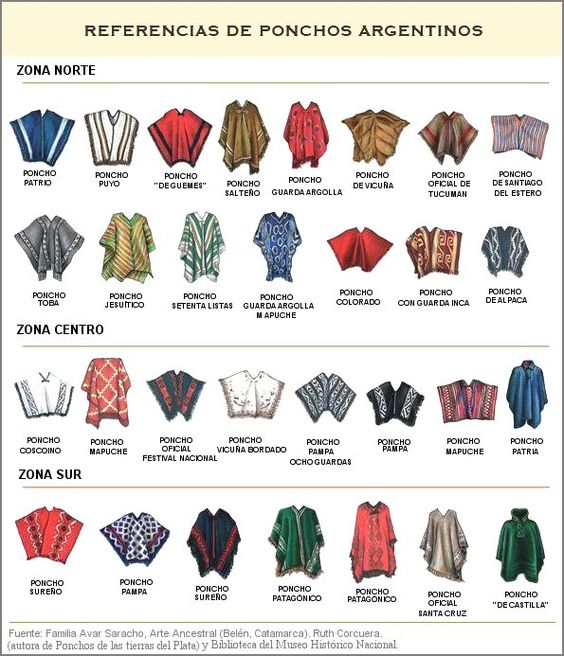 |
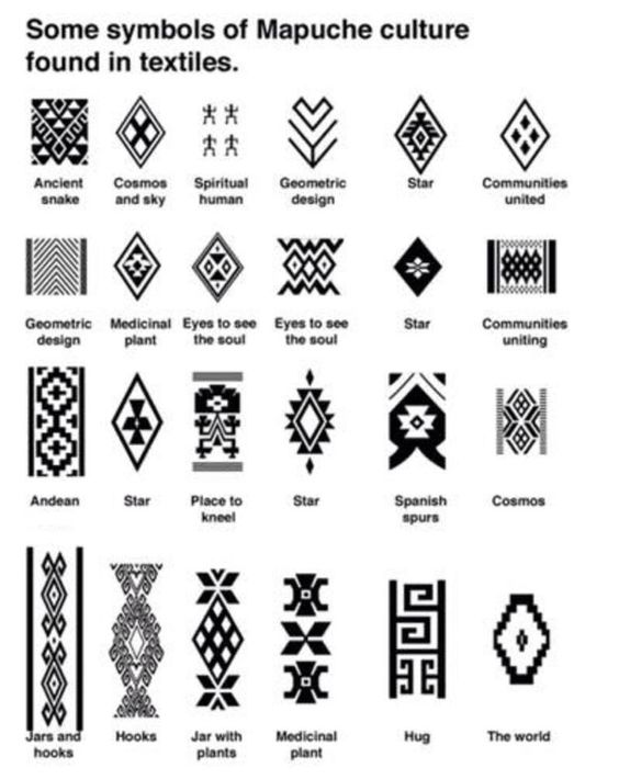
| A chart of traditional Mapuche patterns used in ponchos – it would be an interesting challenge to replicate these patterns using graph paper – cross curricular link with maths there!
See also http://matematicas-maravillosas.blogspot.co.uk/2011/07/puede-notarse-que-las-figuras-que.html |
 |
| A colour wheel giving some of the symbolism of wearing that particular colour. | 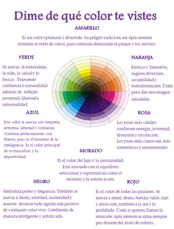 |
6. Using the above, design your own poncho using traditional colours and patterns:
Mi poncho es …… El rojo significa ….. Tiene estampa…… Es como el poncho de ….
(A similar activity can be found on Light Bulb Languages for flags/banderas)
Here’s a blank poncho that you might use (or you might just like to draw your own!) NB this poncho is the wrong shape as is this one.
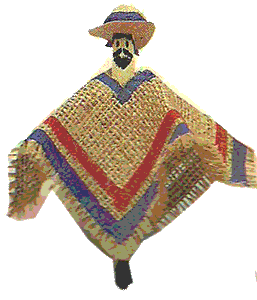
You could also make a mini gaucho out of a lolly stick or old fashioned clothes peg like the chap on the right!
 |
|---|
I’ve saved some links on Pinterest – Argentinian ponchos including the image below.
If you like the original map, I’ve also found maps of Argentina giving animals according to region and mates too as well as a beautiful vintage map of Argentina with images depicting the terrain, industry, dress and wildlife of each area and an info graphic of ‘La Argentina, el país dé los seis continentes’, the slogan of an advertising campaign I’m 1998 that emphasises the diversity of Argentina. Finally, a map of 24 ‘must visit’ places in Argentina. Having never been there, I couldn’t say whether it’s a comprehensive list or whether there are other places to add?

¡24 destinos únicos en la Argentina!


